Directions & Maps

|
COMING FROM CAIRO, GA,
From the intersection of Hwy 84 and State Road 111 (N. Broad St.) you will travel WEST 5.6 miles on 84. As you go 4 to 5 miles out of town, you will cross over the three bridges of Tired Creek. Get in the left lane and. The next bridge is over Wolf Creek. Look for the brown sign identifying the Preserve. There will be a left-turn lane. Turn left onto Wolf Creek Rd. At the top of the hill only a few hundred feet from 84, there will be, ON THE LEFT, (across from a house: 164 Wolf Creek Rd.), the gate which you enter for parking. FROM THOMASVILLE, Take Hwy 84 West through Cairo. See directions from Cairo. FROM TALLAHASSEE, Take Hwy 319 North into GA, turn left on GA 93. Follow 93 through Cairo to Hwy 84. See directions from Cairo. For a more scenic route: Take Meridian Rd., past Birdsong Nature Center in Grady County, GA turn left on GA 93. Continue north through Cairo, until you come to Hwy 84. See directions from Cairo. FROM THE WEST, Take 84 East through Whigham. In about 2 miles, look for the small brown sign that identifies the Preserve, turn right, up the hill to gate on the left. |
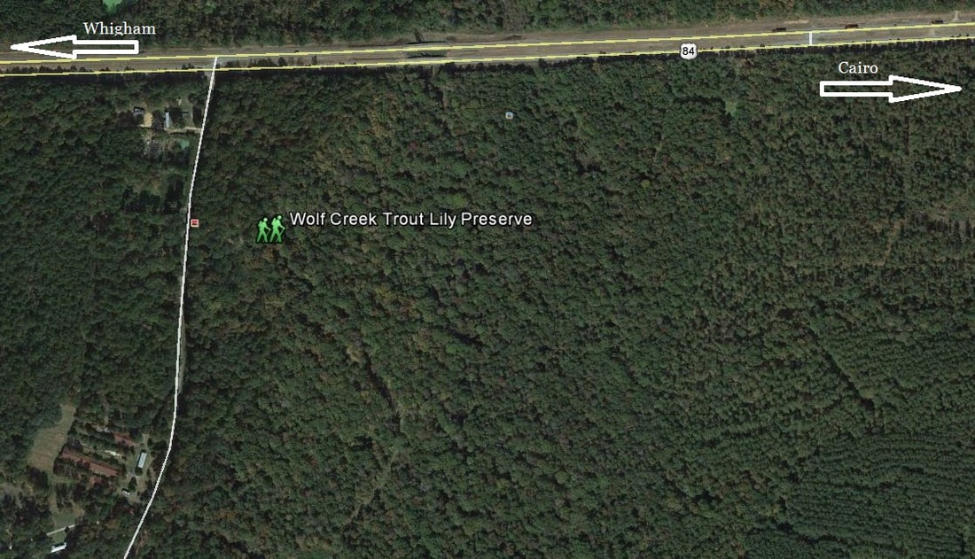
Satellite Image of Wolf Creek Trout Lily Preserve
Wolf Creek Trout Lily Preserve is located off US Hwy 84 approximately five miles west of Cairo and two miles east of Whigham, GA.
The main entrance is on the east side of Wolf Creek Road.
The main entrance is on the east side of Wolf Creek Road.

How Avenza Maps Work
The Avenza Maps® app uses your device's built-in GPS to locate you even when you are out of range of a network or internet connection. Maps used in the app are geospatial PDFs, GeoPDF or GeoTIFFs. You can import your own, or find just the right one in the Avenza Map Store. Use the mapping tools in the app to add GPS tracks, add place marks, add photos and more. Avenza Maps is free for recreational use. If you need it for work, you'll need an Avenza Maps Pro Subscription. Browse almost a million free and paid maps in the Avenza Map Store. Refine your search by location, activity or map publisher and download as many maps as you need. Already have a map? You can load up to 3 into Avenza Maps (more with a paid subscription).
Directions
1. Download the APP in the APP STORE or GOOGLE PLAY onto your mobile phone.
2. Open the Wolf Creek website on your mobile phone and find the Visitors_TrailMap PDF.
3. Press and hold the map PDF to open the popup window that contains various modes for sharing and storing information, such as Message, Mail, Add to Notes and Copy to Avenza Maps.
4. Click open
Copy to Avenza Maps
5. Visitor_Trail Map will automatically be loaded/added to the map list. It may take a few seconds.
6. You are ready to hike and navigate the trails of Wolf Creek using your Avenza Map app.
|
| ||||